
North Louisiana Facing Dangerous, Dry Heat to End of August
If you thought Northwest Louisiana was simply dealing with another stretch of August heat, NOAA says there may be a bigger problem developing.
Shreveport and Northwest Louisiana could be facing as many as 15 days straight of triple-digit heat as a powerful weather pattern settles over the ArkLaTex. Temperatures are expected to push past 100 degrees by the end of this week, and longer-range forecasts suggest the extreme heat could hang around through much of the rest of August.
Richard Lewelling of The Weather Channel told KEEL News on Tuesday that this may not be a typical Louisiana heat wave that breaks after a few miserable afternoons.
“A prolonged heat and rapid onset drought will grip the region as we move on through the rest of the month,” Lewelling warned.
That is a pretty strong statement, especially considering just how hot he expects it to get.
“We face extreme heat beginning late this week and continuing all the way through late next week with a major heat wave that will grip the region,” Lewelling said.
READ MORE: Caddo Parish Issues Burn Ban
Lewelling says daytime temperatures could range between 100 and 105 degrees, while heat index values could climb between 110 and 115 next week.
Even more concerning is what happens after next week.
Lewelling says there is “no major relief in sight,” with above-normal temperatures potentially lasting through the remainder of August.
The Climate Prediction Center is warning that prolonged heat across the South could help produce rapid-onset drought conditions, with the Lower Mississippi Valley among the areas being watched through late August.
NOAA Sees More Than Just Hot Afternoons
The latest Climate Prediction Center key message, updated August 11, shows a greater than 70 percent chance of above-normal temperatures across parts of the south-central and southeastern United States from August 19 through August 25.
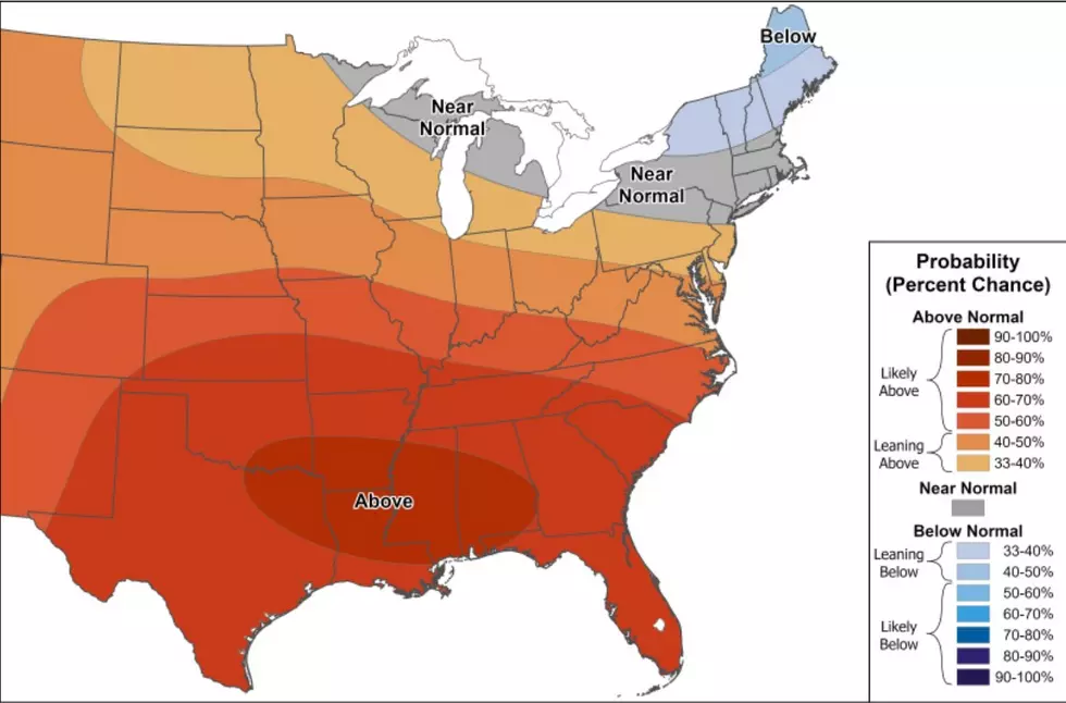
Perhaps more important for Louisiana, forecasters say there is no major break showing up behind that heat. Computer guidance suggests above-normal temperatures could continue through the end of August.
Rapid-Onset Drought Is the New Concern
That kind of heat becomes more than uncomfortable when rain is scarce; it becomes dangerous. NOAA points to areas running precipitation deficits of more than two inches during the past 30 days, combined with expectations for continued heat and limited rainfall.
Unlike a drought that slowly builds over several months, rapid-onset drought can develop quickly when extreme heat pulls moisture from soil and vegetation faster than rainfall can replace it.
Shreveport Forecasters Are Watching the Same Trend
The National Weather Service in Shreveport is seeing signs locally that fit the larger NOAA outlook.
Its August 11 forecast discussion says most of the region is expected to stay dry through the week and into the weekend. Forecasters specifically warned that hotter and drier conditions could worsen drought conditions and increase fire-weather concerns.
A Heat Advisory is already in effect across the Shreveport forecast area through Friday evening, with some locations expected to reach heat index values around 105 degrees.

For Northwest Louisiana, the takeaway may be that the thermometer is only part of the story. If the heat keeps coming without meaningful rainfall, lawns, pastures, crops and wooded areas could begin showing the effects quickly.
The next couple of weeks may tell us whether this becomes simply a memorable heat wave or the beginning of a much drier end to summer.